- Acanthophoenix
- Acrocomia
- Actinokentia
- Actinorhytis
- Adonidia
- Aiphanes
- Allagoptera
- Ammandra
- Aphandra
- Archontophoenix
- Areca
- Arenga
- Asterogyne
- Astrocaryum
- Attalea
- Bactris
- Balaka
- Barcella
- Basselinia
- Beccariophoenix
- Bismarckia
- Borassodendron
- Borassus
- Brassiophoenix
- Burretiokentia
- Butia
- Calamus
- Calyptrocalyx
- Calyptrogyne
- Calyptronoma
- Carpentaria
- Carpoxylon
- Caryota
- Ceratolobus
- Chamaedorea
- Chamaerops
- Chambeyronia
- Chelyocarpus
- Chuniophoenix
- Clinosperma
- Coccothrinax
- Cocos
- Corypha
- Cryosophila
- Cyphokentia
- Cyphophoenix
- Cyphosperma
- Daemonorops
- Deckenia
- Desmoncus
- Dictyocaryum
- Drymophloeus
- Dypsis
- Elaeis
- Eleiodoxa
- Eremospatha
- Eugeissona
- Euterpe
- Gaussia
- Geonoma
- Guihaia
- Hedyscepe
- Hemithrinax
- Howea
- Hyophorbe
- Hyospathe
- Hyphaene
- Iriartea
- Iriartella
- Itaya
- Jailoloa
- Johannesteijsmannia
- Juania
- Jubaea
- Jubaeopsis
- Kentiopsis
- Kerriodoxa
- Korthalsia
- Laccospadix
- Laccosperma
- Lanonia
- Latania
- Lemurophoenix
- Leopoldinia
- Lepidocaryum
- Lepidorrhachis
- Leucothrinax
- Licuala
- Linospadix
- Livistona
- Lodoicea
- Lytocaryum
- Manicaria
- Manjekia
- Marojejya
- Masoala
- Mauritia
- Mauritiella
- Maxburretia
- Medemia
- Metroxylon
- Myrialepis
- Nannorrhops
- Nenga
- Neonicholsonia
- Neoveitchia
- Nephrosperma
- Normanbya
- Nypa
- Oenocarpus
- Oncocalamus
- Oncosperma
- Orania
- Oraniopsis
- Parajubaea
- Pelagodoxa
- Phoenicophorium
- Phoenix
- Pholidocarpus
- Pholidostachys
- Physokentia
- Phytelephas
- Pigafetta
- Pinanga
- Plectocomia
- Plectocomiopsis
- Podococcus
- Pogonotium
- Ponapea
- Prestoea
- Pseudophoenix
- Ptychococcus
- Ptychosperma
- Raphia
- Ravenea
- Reinhardtia
- Retispatha
- Rhapidophyllum
- Rhapis
- Rhopalostylis
- Roscheria
- Roystonea
- Sabal
- Sabinaria
- Salacca
- Saribus
- Satakentia
- Satranala
- Schippia
- Sclerosperma
- Socratea
- Solfia
- Sommieria
- Syagrus
- Synechanthus
- Tahina
- Tectiphiala
- Thrinax
- Trachycarpus
- Trithrinax
- Veitchia
- Verschaffeltia
- Voanioala
- Wallaceodoxa
- Wallichia
- Welfia
- Wendlandiella
- Wettinia
- Wodyetia
- Zombia
- x Jubautia splendens
- ?? Acoelorrhaphe
- ?? Bentinckia
- ?? Brahea
- ?? Clinostigma
- ?? Colpothrinax
- ?? Copernicia
- ?? Cyrtostachys
- ?? Dictyosperma
- ?? Dransfieldia
- ?? Heterospathe
- ?? Hydriastele
- ?? Iguanura
- ?? Incertae sedis & excluded names
- ?? Loxococcus
- ?? Micronoma
- ?? Paripon
- ?? Pritchardia
- ?? Rhopaloblaste
- ?? Serenoa
- ?? Washingtonia
Main menu

Distribution
In Venezuela, on the Cordillera de la Costa (Aragua, Miranda, Distrito Federal, Táchira), most commonly on the South slopes that head to the continent, and on the highest crests, and in Colombia, on the Northwestern side of the Sierra Nevada de Santa Marta (Magdalena, Guajira) and Serranía de Perijá, in montane rain forest, at (1900-)2200-2800 m, usually forming groups of many individuals. (Maria Jose Sanin & Gloria Geleano in Phytotaxa 34 (2011))A
Discussion
- Ceroxylon ceriferum is diagnosed by having a crown with few leaves arched and twisted 90° on distal portion thereby holding the pinnae in a vertical position by its regularly arranged pinnae, almost horizontal and straight, small staminate flowers with 7 to 12 stamens, and fruit with exocarp minutely granulose.
Karsten first proposed the name Klopstockia cerifera in 1847, in his monograph on the vegetative organs of palms, in which he included an illustration of a seedling. He sent a detailed description of the palm to Martius, who published it under the name Ceroxylon klopstockia, citing Karten?s letter and monograph. As Karsten's binomial is validly published, Martius- Ceroxylon klopstockia is illegitimate, being a superfluous name based on the same type. (Maria Jose Sanin & Gloria Geleano in Phytotaxa 34 (2011))A
Conservation
- In Venezuela, C. ceriferum has been recorded as Endangered according to the IUCN criteria, mainly due to the extraction of leaves for use during Palm Sunday in Holy Week, and demographic studies on this species have been seriously recommended (Llamosas et al. 2003). In Colombia the habitat of C. ceriferum has been altered to some extent, and the formerly large and healthy populations are today dramatically reduced. Fortunately, there are some areas of reserve that have been established in the last 20 years that protect some parts of the population. According to general observations, only populations on the steepest terrains have a well-developed structure, including different size classes, while those on the flat terrains consist of mostly old individuals with few seedlings and juveniles, since those areas were cutoff more than 20 years ago for agricultural purposes, and only the adults that were already present were left standing. The offspring that is present now at the area was probably produced by the aldult individuals that attained sexual maturity in the last two decades. (Maria Jose Sanin & Gloria Geleano in Phytotaxa 34 (2011))A
Common Name
- Palma de cera, palma de ramo (Colombia), siri (Arhuaco, Colombia), ramo bendito (Venezuela). (Maria Jose Sanin & Gloria Geleano in Phytotaxa 34 (2011))A
Description
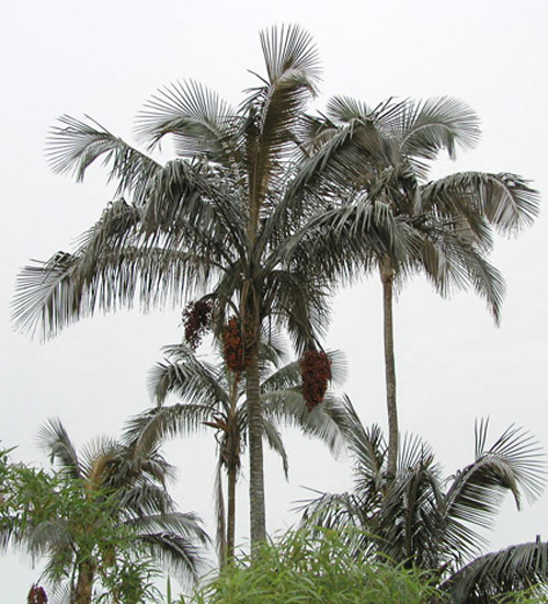
- Stem 7-10(-25)m tall, 14.5-28.0 cm diam., silverish, covered with a rather thin layer of wax.
Leaves 8-12, horizontal or ascendant and arched, in a hemispheric crown, sometimes with on old leaf hanging; sheath 67-120(-180) cm long, 5.0-6.5 cm wide at apex, covered with thick, brownish, persistent indumentum; petiole 15-50 × 4.5-5.0 cm, wide, adaxially concave to flat on top, glabrescent, or with persistent, scale bases and some remnant scales towards margins, rounded abaxially, covered with appressed, grey-brownish scales; rachis 180-330 cm long, twisted 90° on distal portion thereby holding the pinnae in a vertical position, adaxially flattened in ?-? of its length, then sharp, without a notorious hastula-like projection, the surface glabrescent with scarce remnants of scales, abaxially covered with thick and whitish indumentum; pinnae 86-116 on each side, regularly arranged in one plane, horizontal and straight to pendulous in the basal part of the leaf , the apices equilateral to briefly inequilateral by 0.2-0.5 cm, adaxial midrib and surface glabrous, abaxial midrib covered with one row of deciduous, translucent, thin, 1-7 mm scales, surface covered with silvery white to cream or brown, membranaceaous scales, immersed in furrows, arranged in closely adjacent, 0.1-0.3 mm wide rows, hiding leaf surface; the most basal filiform pinnae16-48 × 0.2-0.9 cm, basal pinnae (10th from base) 40-64 × 0.6-2.1 cm, middle pinnae 57-91 × 2.4-5.5 cm, (0.7-)1.8-2.8(-4.0) cm apart, apical pinnae 17-25 × 0.2-0.8 cm, never united along margins.
Staminate inflorescences 1 or 2 at one time, erect; peduncle 83-96 cm long, covered with light-brown indumentum; prophyll 34-36 cm long, 13-14 cm wide; peduncular bracts 6-7, 46-167 × 7-12 cm, covered with persistent, brown to light-brown indumentum, and an additional, smaller, more distally inserted, membranaceous bract; rachis 44-73 cm long, with 52-75 branches, rachis and branches glabrescent, longest branches 34-36 cm long.
Pistillate inflorescences 2-8 at one time, erect in flower, becoming arched and pendulous in fruit; peduncle 90-143 cm long, 1.6-3.0 cm wide at apex, toward the base covered with persistent, woolly, light brown indumentum, glabrescent and green toward the apex; prophyll 25-42 cm long, 9-12 cm wide at base; peduncular bracts 6, 38-169 × 7-11 cm, and an additional, smaller, more distally inserted, 9-25 cm bract, all bracts covered with thick, brown or grey indumentum; rachis 49-90(-120) cm long, with 45-72 branches, subtended by a 0.5-3.2 mm long, membranaceous, acuminate bract, longest branches near the base, 26-49 cm, rachis and branches glabrescent.
Staminate flowers: sepals 3(-5), elliptical-acuminate, 1.0-1.5 mm, connate in 0.5 mm (1/3-½ of total length), reaching or exceeding edge of corolla tube; petals 3, elliptical-acuminate to alleznate, 3.5-6.0 mm, including a 1-2 mm acumen, connate in 0.5-1.0 mm; stamens (7-)8-10(-12), 3-6 antisepalous, and 3-6(-9) antipetalous, filaments 1.8-2.0 mm, inserted at basal 2/5-3/5 portion of anther, anthers 2.0-2.2 mm long, connective not projected.
Pistillate flowers: sepals 3, elliptical-acuminate, 1.0-1.5 mm long, connate in 0.8-1.0 mm (½-2/3 of the total length), not reaching edge of corolla tube; petals 3, elliptical-subulate, 4-5 mm, including a narrow, 1 mm acumen, connate up to 1 mm; staminodes 9-12, with very thick, 0.5 mm filaments, and abortive anthers 1.5-2.0 mm.
Fruits globose, orange-red when ripe, 1.4-1.5 cm diam., exocarp minutely granulose; fruiting perianth with sepals triangular-acuminate, 1-2 mm, connate in 0.5-1.0, lobes reaching or exceeding edge of corolla tube; petals elliptical-subulate, 3.5-5.0 mm long, including an acumen of 1(-2) mm long, widened at base, connate in 0.8-1.5 mm.
Seeds ca. 1 cm diam. (Maria Jose Sanin & Gloria Geleano in Phytotaxa 34 (2011))A
Materials Examined
- COLOMBIA. Cesar: Serranía de Perijá, Municipality of Manaure, "El Cinco", Finca Vistahermosa, Southeast of the road, 72° 57' W, 10° 26'N, 2235 m alt., 14 November 1993, M.Pardo et al. 277 (st.fl.) (COL); up from Los Eucaliptos, 3 km along road, 72° 57' W, 10° 26' N, 2640 m alt., 16 November 1993, M.Pardo et al. 378 (st.fl.) (COL). Guajira: Cerro Pintado, El Espejo region, 2700 m, 12 November 1985, H. Cuadros 2360 (pist.fl.) (MO). Magdalena: Municipality of Santa Marta, corregimiento Minca, vereda Bellavista, Sierra Nevada de Santa Marta, Cerro Kennedy,11°05' N 74°01' W, 2620 m, 14 January 1989, A. Gentry & H. Cuadros 64664 (immat.fr.) (NY, MO); Cuchilla de San Lorenzo, near La Lagunita, on the way to Cerro Kenedy, 2475 m, January - 1917, M. T. Dawe 703 (st.fl.) (K); 5 July 1920, M. T. Dawe 795 (pist.fl., immat.fr.) (K); "Cleveland", above hacienda Cinncinati, ca. 2100 m, 5 August 1946, M. B.Foster & E. Smith 1416 (st.fl.) (COL); between Cerro Quemado and Cerro San Lorenzo, 2600?2800 m, 17 April 1959, Romero-Castañeda 7779 (immat.fr.) (COL); 2595 m alt., 11° 06' 38" N, 74° 03' 06.6" W, 2 November 2008, G. Galeano et al. 7583 (mat.fr.) (COL, HUA), G. Galeano et al. 7584 (st.fl.) (COL), 7585(pist.fl., immat.fr.) (COL); Cebolleta, 2400 m, 2 February 1959, Romero-Castañeda 7211 (st.fl.) (COL), 7218(fr.) (COL).VENEZUELA. Distrito Federal: between El Junquito and Colonia Tovar, ca. 67° 15' W, 10° 25' N, cloud forest, 2300 m, 6 March 1968, G. Wessels Boer et al. 2442 (immat.fr.) (NY), 2443 (st.fl.) (NY); 2000 m, 1 October 1963, J. Steyermark 91612 (fr.) (BH, NY); 2400 m, 12 February 1966, J. Steyermark 94797(st.fl.) (US); Colonia Tovar, XI?1852, M. Moritz 1672 (st.fl.) (BM, P); cloud forest on ridge West of El Junquito, 4 April 1962, J. Steyermark 90867 (pist.fl.) (NY). Táchira: source of the Quininarí River, near "Las Copas", at the base of la Peña de Pata de Judío, 15 km South of San Vicente de la Revancha, 30 km South of Alquitrana, Southeast of Santa Ana, 2400 m, 21 January 1968, J. Steyermark et al. 101256 (fr.) (BH); 25 km S of Delicias. (aprox.) 07°25' N 72° 30' W, 2450 m, 3 March 1968, Wessels-Boer et al. 2436 (fr.) (NY) (MERC); Páramo de Zumbador, along road from La Grita to Táriba, 72° 5' W, 7° 55´N, disturbed cloud forest, 2500 m, 2 March 1968, G. Wessels Boer et al. 2433 (st.fl., fr.) (NY). (Maria Jose Sanin & Gloria Geleano in Phytotaxa 34 (2011))A
- Log in to post comments